Civic, Media & Research Desk Updated October 2026

The 41 Critical Houston Flood Factors & Press Resource Kit

The authoritative municipal, hydrological, and consumer defense reference for Greater Houston. Created for broadcast journalists, civic leaders, Super Neighborhood councils, HOAs, and academic researchers.

Home / Tools / Press & Civic Kit

EDITORIAL MANDATE & CITATION PROTOCOL

Free Public Flood Intelligence for Greater Houston

HTX.io operates as an independent, non-commercial public service flood intelligence desk. We synthesize official real-time telemetry from the U.S. Geological Survey (USGS), Harris County Flood Warning System (HCFWS), National Weather Service (NOAA/NWS), and U.S. Army Corps of Engineers (USACE).

No Paywalls or Sponsored Listings Free and fully open to all residents, newsrooms, community organizations, and civic leaders.
Non-Commercial Editorial Firewall Zero lead-bounty auctions, zero sponsored contractor rankings, and zero affiliate kickbacks.
Open Attribution for Media & Research Journalists, educators, and HOAs may cite and quote these 41 factors with link attribution to htx.io.
MASTER CHECKLIST • 01 THROUGH 41

The 41 Critical Houston Flood Factors

Flooding in Houston is not a generic weather phenomenon; it is governed by exact geotechnical realities, municipal right-of-way design standards, hydrodynamic tailwater locks, vehicle displacement physics, and post-storm microbial clocks.

PART I FACTORS 01–09

Houston Hydrology & Terrain Factors

The geological, topographical, and municipal drainage constraints unique to the flat Gulf Coastal Plain.

01 Topography

1-ft/Mile Flat Plain Slope

Gulf Coastal Plain elevation drops only ~1 foot per mile, preventing gravitational runoff.

Houston sits on an exceptionally flat coastal delta. Unlike hilly or mountainous terrain where gravity quickly pulls runoff into swift downstream gorges, Houston stormwater moves with extreme sluggishness. Overland flow velocities are minimal, which causes stormwater to back up regionally across vast surface areas rather than draining away.

Rule of Thumb: Water in Houston cannot outrun rainfall by gravity; it pools horizontally across miles.
02 Soil Science

Impermeable Beaumont Gumbo Clay

Native expansive clay soils swell instantly on wetting, dropping percolation to near zero.

Houston's regional soil profile is dominated by the Beaumont and Lake Charles clay formations—locally called 'black gumbo.' While dry clay develops deep surface fissures, the very first quarter-inch of precipitation causes the montmorillonite clay platelets to swell shut. Infiltration rates plummet to under 0.05 inches per hour, converting residential lawns into virtually impermeable surfaces.

Rule of Thumb: A suburban lawn in Houston sheds water almost as fast as a concrete driveway once saturated.
03 Municipal Civil Infrastructure

1.5 in/hr Underground Pipe Limit

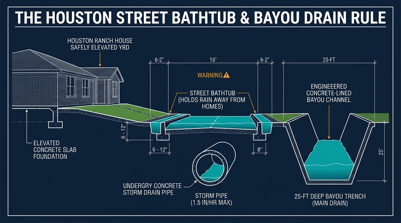
Subsurface storm sewer mains are hydraulically sized for only a 2-year storm (~1.5–2.0 in/hr).

City of Houston and Harris County drainage criteria design neighborhood underground storm conduits to convey a standard 2-year to 5-year storm frequency. Rainfall exceeding approximately 1.5 to 2.0 inches in one hour immediately surpasses pipe intake capacities. Any surplus precipitation is engineered to remain above ground on street rights-of-way.

Rule of Thumb: Any rainfall burst over 2 inches in 60 minutes guarantees water standing in neighborhood streets.
04 Drainage Criteria

Street 'Bathtub' Right-of-Way Detention

Municipal drainage code deliberately uses residential streets as secondary detention basins.

Houston roadway engineering deliberately relies on streets to serve as secondary stormwater storage vessels between curbs. Curbs, crowns, and roadway inverts are designed to hold 6 to 12 inches of water curb-to-curb during torrential downpours. This prevents water from entering home foundations, provided the home's finished slab sits above the crown of the roadway.

Rule of Thumb: Streets are designed to flood before houses do. High water on a street is the system working as designed.
05 Bayou Hydraulics

25-ft Bayou Channel Bankfull Limit

Bayou channels have rigid, defined cross-sectional storage before spilling out of banks.

Houston's 22 major bayous (including Buffalo, Braes, White Oak, Greens, and Sims) operate as regional arterial open drainage channels with typical channel depths of 20 to 28 feet. Once rising water reaches bankfull stage, channel conveyance velocity slows due to boundary friction against overbanks, rapidly backing water into adjoining residential floodplains.

Rule of Thumb: When a bayou reaches 90% bank capacity, tributary gravity drainage stops completely.
06 Hydrostatic Head

'Tailwater Lock' Outfall Backpressure

Elevated bayou stages submerge neighborhood outfalls, trapping street stormwater in place.

When a receiving bayou rises above the elevation of neighborhood storm sewer discharge headwalls, positive hydrostatic head creates 'tailwater lock.' Gravity outfalls cannot discharge against the higher bayou water surface elevation; flap gates are forced shut or water flows in reverse. Neighborhood streets stay submerged even after rainfall completely ceases.

Rule of Thumb: Streets can remain flooded for hours after skies clear if the receiving bayou is still cresting.
07 USACE Dam Operations

Addicks & Barker Pool Elevation & Releases

US Army Corps reservoir operations balance West Houston impoundments against Buffalo Bayou.

Built by the USACE in the 1940s, Addicks and Barker reservoirs capture upstream runoff across 130+ square miles. As pool elevations climb toward uncontrolled spillway crests, the Corps must open sluice gates into Buffalo Bayou. Gate releases of 4,000–16,000 cfs sustain elevated flood stages for weeks along Memorial, the Energy Corridor, and Downtown.

Rule of Thumb: Upstream reservoir releases can flood West Houston neighborhoods days after the storm has left Texas.
08 River Authority

Lake Conroe & Lake Houston SJRA Releases

Upstream San Jacinto River dam releases cascade south into Kingwood, Humble, and Crosby.

During major regional rainfall events across Montgomery and Walker counties, the San Jacinto River Authority (SJRA) must open tainter gates at Lake Conroe dam to prevent structural overtopping. Massive discharges flow down the West Fork San Jacinto River, converging with East Fork flows to overwhelm Lake Houston and inundate low-lying communities in northeast Harris County.

Rule of Thumb: Kingwood and Humble flood risks are governed by Montgomery County rainfall and dam gate releases.
09 Tidal Hydrodynamics

Galveston Bay Wind Tide & Surge Backwater

Southeasterly tropical gale winds push marine surge up the Ship Channel, blocking drainage.

Houston's drainage network discharges southeast into Galveston Bay and the Gulf of Mexico. When tropical cyclones or persistent onshore winds shove Gulf water into the bay, tidal stages rise 3 to 10+ feet above normal. This creates a marine hydraulic barrier at the mouth of the Houston Ship Channel, stopping bayou outflows dead in their tracks.

Rule of Thumb: Onshore tropical winds turn Galveston Bay into a cork that stops all Houston bayous from emptying.
PART II FACTORS 10–17

15-Minute Flash Flood & Underpass Factors

Freeway depressions, rapid hydraulic blind spots, optical illusions, and commercial sheetflow traps.

10 Freeway Depressions

Sunken Freeway & Rail Underpass Funnel

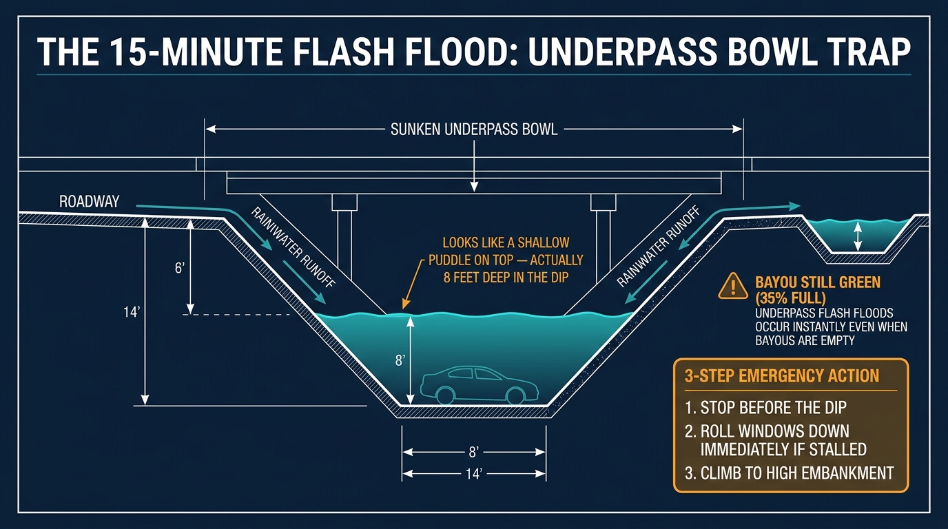
Highway underpasses dip 10 to 18 feet below natural grade, acting as giant stormwater funnels.

Houston highways and frontage roads frequently dip down to pass beneath overhead railroad lines and cross-arterials. These underpasses sit in deep topographic bowls 10 to 18 feet below the surrounding grade. Surface runoff from surrounding multi-acre paved interchanges flows by gravity straight into the lowest point of the bowl.

Rule of Thumb: Freeway underpasses accumulate water 10 times faster than adjacent surface lanes.
11 Sensor Latency

Green Bayou Gauge Flash-Flood Blind Spot

Bayou gauges measure broad watershed runoff over hours, missing 15-minute roadway sumps.

Regional USGS and Harris County Flood Warning System stream gauges measure stream levels across massive multi-square-mile watersheds. While bayou gauges may show 'normal green' stages for hours into a storm, localized cloudbursts can submerge an underpass or roadway depression under 8 feet of water within 15 minutes. Motorists checking bayou gauges get a lethal false sense of security.

Rule of Thumb: A green bayou gauge does not mean roadways are clear. Underpasses flood in 15 minutes.
12 Visual Perception

Murky Water Optical Illusion

Sediment-laden brown water hides 8-foot road drops by creating a flat mirror surface.

Houston stormwater carries massive loads of suspended clay, oil, and organic silt. This turns floodwater completely opaque brown. Because turbid water has high surface tension and zero light penetration, a roadway dip filled with 10 feet of water looks virtually identical to a 1-inch puddle across flat asphalt from behind a windshield.

Rule of Thumb: If you cannot see the white roadway stripes painted on asphalt, the water is too deep to cross.
13 Nighttime Driving

Nighttime Headlight Glare Reflection

Headlights reflect off water surfaces at flat incident angles, concealing submerged chasms.

At night, standard halogen and LED headlights strike flat water surfaces at low incident angles. Rather than penetrating and illuminating the depth of the road beneath, the light beam skips and reflects away into the darkness. Drivers cannot perceive the transition from wet asphalt to 6 feet of standing water until the vehicle's front bumper dives under.

Rule of Thumb: Never drive through unlit standing water at night. It is mathematically impossible to judge depth.
14 Mechanical Lift

Underpass Pump Station Power Failure

TxDOT pump stations fail when electrical grids trip or intake trash screens get choked.

Sunken highway underpasses rely on high-capacity electric lift pumps to evacuate stormwater up into elevated gravity storm sewers. During severe storms, electrical feeder lines trip, backup generators fail to sync, or intake trash screens get blinded by floating tree branches, mattress debris, and automotive plastics, knocking pumps offline precisely when rainfall peaks.

Rule of Thumb: Never assume a freeway pump is running during a severe thunderstorm or hurricane.
15 Trench Freeways

Depressed Freeway Trenches as Canals

US-59 through Montrose and SH-288 operate as unintended deep detention canals.

Freeways constructed in subterranean cut trenches—most notably I-69/US-59 through the Montrose/Museum District corridor and SH-288 near the Texas Medical Center—sit up to 25 feet below surrounding surface grades. When tributary drainage capacity is exceeded, these multi-mile trenches transform into deep, slow-moving rivers, submerging vehicles and trapping drivers.

Rule of Thumb: Stay completely off depressed freeway trenches when heavy tropical storm bands approach.
16 Turnaround Traps

Feeder Road Texas U-Turn Dips

Texas U-turn lanes dip down beneath bridge abutments, forming sudden water traps.

Texas-style continuous turnaround lanes allow frontage road traffic to reverse direction under highway overpasses without stopping at traffic signals. To achieve vertical clearance under bridge decks, engineers grade these turnaround lanes 3 to 6 feet lower than both the main lanes and the outer feeder roads, creating an invisible, deep bowl.

Rule of Thumb: Texas U-turns under highway bridges flood long before the main feeder road lanes show water.
17 Commercial Runoff

Sheetflow Velocity off 90% Impervious Hubs

Galleria, TMC, and big-box shopping centers generate rapid, high-velocity overland flow.

Commercial districts like the Galleria, Texas Medical Center, and Greenway Plaza feature upwards of 90% impervious coverage across multi-acre parking lots, retail superstructures, and parking garages. Rainfall cannot infiltrate; it rushes across asphalt as high-velocity sheetflow, overwhelming curb inlets in seconds and inundating perimeter boulevards.

Rule of Thumb: Commercial district perimeter boulevards experience flash sheet flooding within 10 minutes of cloudbursts.
PART III FACTORS 18–24

Vehicle Buoyancy & Driver Survival Factors

The physics of buoyancy, engine hydro-lock, power window egress protocols, and destructive truck wakes.

18 Vehicle Clearance

6-Inch Curb Height Threshold

At 6 inches, moving water reaches vehicle floorboards and causes loss of directional steering.

Standard passenger sedans have ground clearance between 5 and 7 inches. When floodwater reaches 6 inches, water begins contacting the undercarriage, catalytic converter, and lower suspension arms. Drag forces create significant steering resistance, and moving water can begin pushing the vehicle off the roadbed.

Rule of Thumb: Six inches of water will reach the bottom of most passenger cars and stall vehicle electronics.
19 Archimedes' Principle

12-Inch Compact Car Buoyancy (1,500 lbs Lift)

One foot of water displaces air inside the vehicle envelope, generating ~1,500 lbs of buoyant lift.

By Archimedes' principle, a submerged body is buoyed up by a force equal to the weight of displaced liquid. One cubic foot of water weighs 62.4 pounds. A compact car sitting in 12 inches of water displaces enough air volume inside tires, body cavities, and rocker panels to generate roughly 1,500 lbs of upward buoyant force, lifting drive tires off the pavement.

Rule of Thumb: Twelve inches of standing or flowing water will float a compact sedan or small crossover.
20 Truck Flotation

18–24 Inch SUV & Truck Buoyancy

Heavy pickups and SUVs float in 18–24 inches of water because large tires act as pontoons.

Many truck and SUV owners falsely believe their heavy 5,000-lb curb weight protects them from floodwaters. In reality, oversized all-terrain tires and enclosed cabin air volumes act as massive buoyant pontoons. In 18 to 24 inches of water, even full-size pickups lose wheel traction and get swept away by modest currents.

Rule of Thumb: No passenger vehicle, regardless of 4WD or lift kit, can maintain traction in 2 feet of moving water.
21 Powertrain Failure

Engine Air-Intake Hydro-Lock in 18" Water

Low-mounted air scoops suck water directly into engine cylinders, instantly destroying the engine.

Modern aerodynamic automobile design places the cold air intake scoop low in the front fender liner or behind the lower bumper grille—often only 14 to 18 inches above the road. When a car drives into water, the front bumper creates a bow wave that pushes water into the intake. Because water cannot be compressed, piston rods bend or snap instantly, killing engine power, power brakes, and steering.

Rule of Thumb: Hydro-lock destroys the engine in a fraction of a second and immediately strands you in rising water.
22 Emergency Egress

30-Second Power Window Survival Rule

Vehicle electrical systems short within 30–60 seconds; water pressure locks doors shut.

When a car enters deep water, water pressure against exterior door panels exerts hundreds of pounds of force, making it physically impossible for an occupant to open doors. Furthermore, vehicle 12V electrical systems short circuit within 30 to 60 seconds of water ingress. Occupants must roll down power windows immediately before electrical motors fail.

Rule of Thumb: Seatbelt off, window down, out immediately. You have 30 seconds before power windows fail.
23 Life Safety Gear

Center-Console Spring Window Punch

Keep a tungsten spring punch in the center console—never in the glove box or rear trunk.

If electric windows fail before you can lower them, side windows must be shattered. Modern tempered glass cannot be broken with elbows or fists. Every Houston driver should keep a spring-loaded tungsten center punch or rescue tool secured inside the center console within arm's reach. Aim for the lower corner of the side window, never the laminated front windshield.

Rule of Thumb: Keep a glass breaker in the center console. In an emergency, you will not have time to reach the glove box.
24 Hydrodynamic Wake

Bow-Wave Wake Damage into Homes

High-clearance trucks driving through flooded streets throw wakes that breach front doors.

When lifted trucks or emergency vehicles speed down flooded neighborhood streets, they displace hundreds of gallons of water per second, creating a 12-to-24-inch hydrodynamic bow wave. This rolling wave strikes garage doors, breaks weather stripping, and surges over residential front thresholds into homes that had 3 inches of clearance above the standing water.

Rule of Thumb: Driving fast on a flooded residential street sends waves that flood dry neighbors' homes.
PART IV FACTORS 25–33

Home Slab, Drainage & Utility Defense Factors

Slab elevation tolerances, capillary sheetrock wicking, breaker shutoff safety, and backwater sewage locks.

25 Neighborhood Maintenance

Curb Storm-Inlet Grate Clogging

Leaves, pine needles, and floating trash bins blind street grates, raising water 12+ inches.

Subsurface street drains enter through roadside curb grates. During heavy winds and downpours, oak leaves, pine straw, lawn clippings, and toppled plastic garbage bins drift directly against these grates. This creates an impermeable debris mat that blinds the drain, forcing stormwater to pool 12 to 18 inches higher into residential yards and driveways.

Rule of Thumb: Raking curb storm grates clear before and during rainstorms protects your entire block from flooding.
26 Elevation Profile

Driveway Crown vs Street Gutter (+12–18")

Measure the elevation differential between your street gutter invert and your garage slab.

Every Houston homeowner should know the precise elevation profile of their driveway. The vertical rise from the low street gutter to the high garage floor or slab threshold is typically between 12 and 18 inches. This vertical delta represents your home's buffer zone: if street water rises beyond this number, structural inundation is imminent.

Rule of Thumb: Know your driveway rise in inches. When street ponding reaches your driveway crown, deploy barriers.
27 Elevation Certificate

Finished Floor Elevation (FFE) vs Floodplain

The elevation of the top of your concrete slab relative to Base Flood Elevation (BFE).

A home's structural safety during a 100-year or 500-year storm is dictated by its Finished Floor Elevation (FFE). Homes constructed prior to modern floodplain regulations often sit at or below Base Flood Elevation (BFE). Post-Harvey regulations in Harris County mandate new construction slabs sit at least 24 inches above the 500-year floodplain elevation.

Rule of Thumb: Check your home's FEMA Elevation Certificate. Your FFE must sit above Base Flood Elevation to stay dry.
28 Building Materials

Capillary Drywall Wicking (+12–18" Higher)

Gypsum drywall acts like a sponge, pulling water 12 to 18 inches above the standing water line.

Drywall consists of a porous gypsum core sandwiched between organic cellulose paper facings. When floodwater touches drywall, capillary action wicks moisture upward inside wall cavities 12 to 18 inches higher than the standing puddle. Mold begins growing inside the unseen wall cavity even if the visible surface looks dry.

Rule of Thumb: Always flood-cut drywall at least 12 to 24 inches above the visible standing high-water mark.
29 Electrical Safety

Electrical Outlet Height (14" Above Slab)

Standard wall outlets sit 12–16 inches above the floor; water turns standing puddles live.

National Electrical Code (NEC) installs residential wall receptacles approximately 12 to 16 inches above the subfloor. When indoor floodwaters reach this level, water bridges the ungrounded hot and neutral terminals. This can trip branch breakers, but contaminated water with mineral salts can also conduct electrical current across the flooded room, creating lethal shock hazards.

Rule of Thumb: Never walk into standing indoor floodwater if the home's main electrical service breaker is still on.
30 Life Safety Protocol

Main Electrical Breaker Shutoff Protocol

Kill the main electrical disconnect before water enters, standing on dry insulated ground.

If rising water is approaching your foundation, immediately de-energize the entire home at the main exterior service disconnect panel. Stand on a dry board, rubber mat, or elevated dry ladder, wear non-conductive rubber-soled boots and work gloves, and flip the main breaker to OFF. Never touch the breaker box while standing in water or with wet hands.

Rule of Thumb: Kill the main breaker while you still have dry ground to stand on. Do not wait for water at your ankles.
31 Plumbing Defense

Sanitary Sewer Backflow into Toilets

Inundated municipal sewer pipes push raw sewage backward up through ground-floor drains.

During torrential storms, stormwater infiltrates municipal sanitary sewer networks through manhole pickholes and cracked pipes (Inflow & Infiltration / I&I). When sanitary sewer mains become pressurized, raw Category 3 blackwater surges backward through house lateral lines, spewing out of first-floor toilets, bathtub drains, and low shower pans.

Rule of Thumb: Install an exterior sewer backwater check valve on your main waste line to stop blackwater surges.
32 Combustion Hazards

Gas Meter & Water Heater Pilot Submergence

Submerged natural gas regulators and water heater gas valves corrode and leak gas.

When exterior natural gas meters, pressure regulators, or garage water heater burners are submerged, internal diaphragms and safety shutoff valves fill with muddy water and corrode. Attempting to relight a water heater or furnace that was submerged can cause sudden gas leaks or catastrophic explosions. Submerged gas control valves must be replaced.

Rule of Thumb: Never relight a gas appliance that was underwater. Have a licensed plumber replace the gas valve.
33 Masonry Construction

Brick Veneer Weep Holes Behind-Wall Flooding

Exterior brick weep holes sit at slab height, admitting water behind walls before doors breach.

Houston brick veneer homes feature open vertical weep holes spaced every few feet along the lowest brick course to allow condensation to drain. Because these weep holes sit directly on the foundation brick ledge, standing water only 4 to 8 inches high against the home pours through weep holes straight into the wall cavity, flooding insulation before water touches doorways.

Rule of Thumb: Temporary flood dams or sandbags must cover exterior brick weep holes, not just door thresholds.
PART V FACTORS 34–41

Recovery, Mold, Insurance & Scam Factors

The 48-hour mold clock, flood vs wind claim segregation, TDLR legal licensing rules, and debris piling protocols.

34 Biohazard Clock

24-to-48-Hour Mold Colonization Clock

In Houston's 85°F+ heat and 90% humidity, toxic mold spores colonize drywall within 48 hours.

Houston's subtropical post-storm climate provides optimal conditions for toxic fungal proliferation. Spores of Aspergillus, Penicillium, and Stachybotrys chartarum (black mold) germinate on wet cellulose drywall backing and carpet pads within 24 to 48 hours of saturation. Once mold colonies form, structural remediation costs triple.

Rule of Thumb: The mold clock starts the second water enters. Muck out wet sheetrock and carpet within 48 hours.
35 Remediation Standards

Fiberglass vs Closed-Cell Insulation Trap

Wet fiberglass batt insulation collapses into a wet sponge; flood-cut drywall at 2 ft or 4 ft.

When fiberglass batt insulation gets wet, it loses its loft, collapses to the bottom of the stud bay, and retains water indefinitely against wood wall framing, initiating rapid wood rot and mold. Sheetrock must be cut horizontally at either 24 inches or 48 inches (the standard 4-foot drywall seam) to remove wet batts and permit high-velocity air movers to dry studs.

Rule of Thumb: Wet fiberglass insulation can never be salvaged. Cut the drywall and pull the wet batts immediately.
36 Insurance Evidence

High-Water Mark Photos with Tape Measure

Photograph the water line with an extended measuring tape before tearing out walls or furniture.

Before discarding a single item or stripping drywall, photograph the high-water line in every single room. Hold a rigid, readable metal tape measure against the wall, extending from the finished floor to the silt mark, and photograph both wide-angle room shots and close-up numerical readings. NFIP adjusters require verifiable water height proof to substantiate flood claims.

Rule of Thumb: No tape measure photo means no adjuster proof. Document high-water marks in every room first.
37 Contents Claim

Serial & Model Tag Photos of Ruined Appliances

Photograph serial number and model plates on all submerged HVAC and kitchen appliances.

Flood insurance adjusters require explicit proof of make, model, and serial number before reimbursing HVAC compressors, air handlers, furnaces, water heaters, washers, dryers, and refrigerators. Once scrap haulers drag appliances off your curb, you lose the ability to prove their replacement value.

Rule of Thumb: Photograph the silver manufacturer tag on every ruined appliance before dragging it to the street.
38 Claim Separation

Separate NFIP Flood vs Homeowners Wind Claims

Standard homeowners policies exclude flood; file separate claims with flood and wind carriers.

Standard homeowners insurance policies specifically exclude rising surface water or flood damage. Flood coverage is written under separate National Flood Insurance Program (NFIP) or private flood policies. If a hurricane causes both wind/roof damage and rising floodwater, homeowners must file two separate claims with separate adjusters.

Rule of Thumb: Rising water goes to your NFIP flood policy; roof leaks and broken windows go to your homeowners wind policy.
39 Disaster Aid

FEMA Individual Assistance & SBA Loan Windows

Apply immediately at DisasterAssistance.gov; completing SBA forms unlocks FEMA grants.

Following a presidential disaster declaration, homeowners and renters have 60 days to register for FEMA Individual Assistance (IA) at DisasterAssistance.gov. If referred to the Small Business Administration (SBA) for low-interest disaster loan assistance, you MUST complete and submit the application—even if you do not want a loan—to remain eligible for FEMA Other Needs Assistance (ONA).

Rule of Thumb: Always complete the SBA loan packet. Refusing to submit it automatically disqualifies you from FEMA grants.
40 Texas Consumer Law

Texas TDLR Mold Assessment vs Remediation Law

Texas law mandates separation between the inspector (MAC) and the contractor (MRC).

Under Texas Occupations Code Chapter 1958, the Mold Assessment Consultant (MAC) who tests and writes the remediation protocol CANNOT work for or own the Mold Remediation Contractor (MRC) who performs the work. This prevents predatory contractors from writing bloated protocols for their own benefit. Never pay large upfront cash deposits to unvetted, out-of-state contractors.

Rule of Thumb: Never hire a mold company that inspects and remediates on the same job. It is illegal under Texas law.
41 Debris Separation

City of Houston 311 & Harris County Debris Rules

Separate debris into 5 distinct curbside piles in the right-of-way; never block fire hydrants.

FEMA contracted storm debris haulers will reject mixed piles. Homeowners must separate curbside debris into 5 distinct, unbagged piles in the public right-of-way between the curb and sidewalk: (1) Vegetative debris, (2) Construction & demolition materials, (3) White goods / appliances with taped doors, (4) Electronics, and (5) Hazardous chemicals / paints. Keep piles clear of water meters and fire hydrants.

Rule of Thumb: Separate curbside debris into 5 distinct piles. Mixed piles will sit uncollected on your curb for months.
EMBEDDABLE TOOLS & INTEGRATION ASSETS

Civic, Media, HOA & University Resource Kit

Integrate official live telemetry badges and verified Houston flood intelligence directly into your neighborhood portal, university research hub, local news broadcast page, or HOA bulletin.

EMBED BADGE 01

Live Bayou Gauge Alert Badge

Compact, high-contrast status badge for neighborhood HOA sidebars, community newsletters, and local blog headers.

<!-- HTX.io Live Houston Bayou Gauge Badge -->
<a href="https://htx.io/tools/gauges/" target="_blank" rel="noopener" style="display:inline-flex;align-items:center;gap:8px;background:#0f172a;color:#ffffff;padding:8px 14px;border-radius:6px;font-family:Inter,system-ui,sans-serif;font-size:13px;font-weight:600;text-decoration:none;border:1px solid #334155;">
  <span style="display:inline-block;width:8px;height:8px;border-radius:50%;background:#10b981;box-shadow:0 0 6px #10b981;"></span>
  <span>Houston Live Bayou Gauges</span>
  <span style="color:#94a3b8;font-size:11px;font-weight:400;">via HTX.io</span>
</a>
EMBED WIDGET 02

Emergency Flood Intelligence Card

Full-featured emergency triage card with direct links to live bayou stream gauges, 3D watershed profiles, and neighborhood ZIP lookups.

Live Preview:
HTX Flood Intelligence Desk PUBLIC DESK

Real-time USGS & Harris County bayou stream gauges, 3D watershed terrain models, and neighborhood flood risk lookups.

<!-- HTX.io Emergency Flood Intelligence Card -->
<div style="background:#0f172a;color:#f8fafc;border-radius:8px;padding:20px;font-family:Inter,system-ui,sans-serif;border:1px solid #334155;max-width:440px;">
  <div style="display:flex;align-items:center;justify-content:space-between;margin-bottom:12px;">
    <strong style="color:#ffffff;font-size:16px;">HTX Flood Intelligence Desk</strong>
    <span style="background:#e85d04;color:#ffffff;font-size:11px;padding:2px 8px;border-radius:4px;font-weight:700;">PUBLIC DESK</span>
  </div>
  <p style="color:#cbd5e1;font-size:13px;line-height:1.5;margin:0 0 16px 0;">
    Real-time USGS & Harris County bayou stream gauges, 3D watershed terrain models, and neighborhood flood risk lookups.
  </p>
  <div style="display:flex;flex-wrap:wrap;gap:8px;">
    <a href="https://htx.io/tools/gauges/" target="_blank" rel="noopener" style="background:#1e293b;color:#f8fafc;padding:6px 12px;border-radius:4px;font-size:12px;font-weight:600;text-decoration:none;border:1px solid #475569;">Live Gauges &rarr;</a>
    <a href="https://htx.io/tools/zip/" target="_blank" rel="noopener" style="background:#1e293b;color:#f8fafc;padding:6px 12px;border-radius:4px;font-size:12px;font-weight:600;text-decoration:none;border:1px solid #475569;">ZIP Flood Risk &rarr;</a>
    <a href="https://htx.io/areas/" target="_blank" rel="noopener" style="background:#1e293b;color:#f8fafc;padding:6px 12px;border-radius:4px;font-size:12px;font-weight:600;text-decoration:none;border:1px solid #475569;">Watersheds &rarr;</a>
  </div>
</div>
HYPERLINK CITATION 03

Contextual Article & Research Citation

Standard HTML paragraph citation formatted for news stories, university research papers, and civic government documentation.

<!-- HTX.io Standard Contextual Hyperlink -->
<p>For live Houston bayou stream telemetry and neighborhood flood defense resources, visit the <a href="https://htx.io" target="_blank" rel="noopener">HTX.io Houston Flood Resource Desk</a>, consult the <a href="https://htx.io/press/" target="_blank" rel="noopener">41 Critical Houston Flood Factors</a>, or track live gauge data on <a href="https://htx.io/tools/gauges/" target="_blank" rel="noopener">HTX.io Live Bayou Gauges</a>.</p>
CORE PLATFORM ENDPOINTS

HTX.io Public Desk Navigation & Tools

Direct link references to high-traffic, real-time modules on the HTX.io network for easy bookmarking and civic reference.

DIRECT EDITORIAL INBOXES

Press Inquiries & Civic Integration Inboxes

Reach our editorial team for live broadcast interviews, background research briefings, data partnerships, or HOA integrations.

NEWSROOMS • BROADCAST • PRINT

Press & Media Inquiries

For journalist interviews, data citations, broadcast graphics permissions, and urgent post-storm commentary:

  • Rapid response during active Houston tropical and flash flood watches.
  • High-resolution vector assets, logos, and printable infographics.
  • On-the-record background briefings on Houston municipal drainage standards.
HOAS • UNIVERSITIES • CIVIC LEAGUES

Civic & Research Desk

For homeowners associations, Super Neighborhood councils, university researchers, and municipal agencies:

  • Custom neighborhood website embed codes and telemetry widgets.
  • Academic research collaboration, hydrological sensor datasets, and historical storm telemetry.
  • Printed emergency hurricane pack distribution for community centers and senior living facilities.